
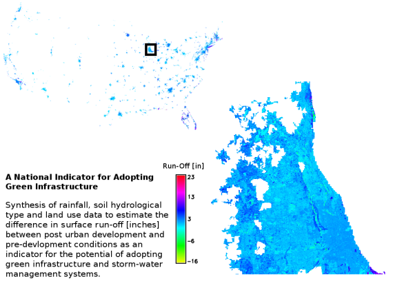
The research work is part of the Stormwater and Mosquito Control Project. The research project aims at the synthesis of various geospatial datasets, (e.g., soil hydrology, current and future land cover, and climatic variables) to develop a national index for the potential of adopting green infrastructure (GI) across urban areas in the US. The main challenge is developing a methodology that accounts for the variable degrees of uncertainty associated with each of the geospatial datasets. Currently, the project team made progress in estimating, in a spatially distributed fashion, the change in surface run-off between the pre-urban development and post development conditions.
The team effort is focused on developing methods to estimate the potential improvement in surface runoff after adopting GI. A main interest of the project team is assessing the uncertainty associated with the multiple degrees of freedoms in selecting the type and specifications of GI on the final index and exposes it to decision makers. Moreover, the team is working on accounting for contingent issues to surface runoff such as environmental regulatory constraints and expected benefits of reducing mosquitoes habitat and associated risk of mosquitoes-borne diseases in the national GI index.
