
This research is focused on fusing geo-located social media with authoritative data for the purpose of monitoring urban land use. A number of recent studies showed that digital foot-prints around built environments, such as geo-located tweets, are promising data sources for characterizing urban land use. However, previous studies analyzed temporal signatures of Twitter users collectively resulting in coarse resolution maps of urban land use. A novel method was designed to complement traditional on-site surveys, specifically in the era where rapid changes in metropolitan land utilization exceed periodic surveys. The results of this project revealed that mechanistic understanding of Twitter users’ mobility patterns led to an optimum integration of volunteered and authoritative maps, and allowed for characterizing land use at the level of city parcels.
Continue reading
Remote Sensing
A National Index for the Potential of Adopting Green Infrastructure across Urban Areas
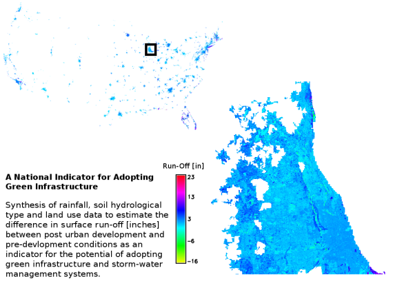
The research work is part of the Stormwater and Mosquito Control Project. The research project aims at the synthesis of various geospatial datasets, (e.g., soil hydrology, current and future land cover, and climatic variables) to develop a national index for the potential of adopting green infrastructure (GI) across urban areas in the US. The main challenge is developing a methodology that accounts for the variable degrees of uncertainty associated with each of the geospatial datasets. Currently, the project team made progress in estimating, in a spatially distributed fashion, the change in surface run-off between the pre-urban development and post development conditions.
